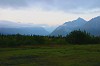
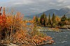
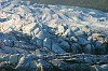
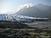
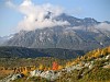
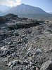
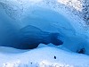
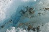
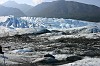
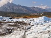
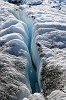
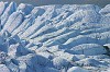
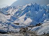
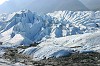
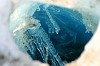
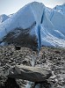
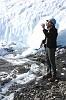
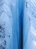
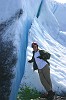
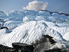
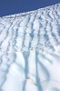
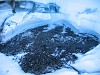
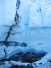
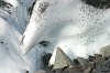
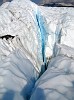
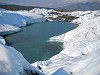
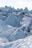
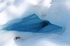
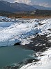
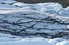
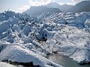
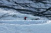
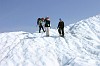
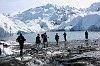
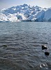
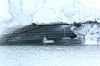
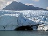
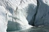
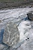
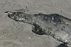
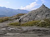
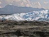
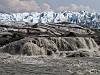
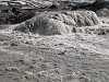
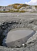
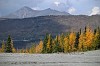
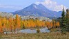
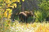
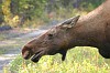
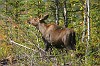
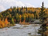
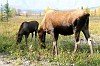
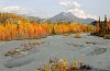
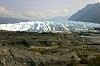
Day 2 (Monday, 8/30/2004)

Following a hearty wilderness breakfast at the MVL, we vacated the long house, loaded up the van, and backtracked a few miles down the road to the Matanuska Glacier.  "The Mat" is a 24-mile long valley glacier, averaging about two miles in width with a four-mile-wide terminus.  It is an active glacier, advancing at an overall rate of 1 foot per day, and ice takes 250 years to completely traverse the length of the glacier from formation to terminus.  However, although the glacier continuously advances, the glacial margin is retreating from year to year, and thus the glacier is shrinking as it advances.  Most of Alaska's glaciers are shrinking due to global warming, but a few are still growing.

The Mat is one of the few glaciers in Alaska that is accessible by car-- for a small fee paid to the owner of the access road.  At the end of the road lies a small guide shack, maintained by MICA guides, which sits perched atop the abandoned terminal moraine that The Mat has kicked up through decades of slow retreat.  The terminus now lies hundreds of yards back from where it was in the 1970's.  We were led by two guides, one of which was a charming New Zealander who had picked up the sport of glacier trekking in the Southern Alps of the South Isle (the Misty Mountains in "The Lord of the Rings.")

Our trek began with a brief hike over the powdery grey silt and gravel that forms the terminal moraine.  Our guide explained that the glacial ice lies only a few feet or less below the surface of the moraine, so the moraine is constantly shifting and subsiding with the ebb and flow of the seasons and even with the rising and setting of the sun.  New paths have to be picked through it daily as the sun warms the ice.  We arrived at a picnic table, perched precariously on the edge of the ice, where we fitted crampons onto our boots for the remainder of the hike.

Our hike gave us just a taste of this vast and rapidly-changing ecosystem.  We saw towering monoliths of blue ice (glacial "serac"), seemingly bottomless holes ("moulin"), several waterfalls, and a huge hidden lake entirely surrounded by the Mat.  Upon our return to the guide shack, we ate lunch and wandered around the terminus while waiting for the group of ice climbers to return.  Jen and Keith and I hiked down to one of the glacial vents, places where meltwater exits from the bottom of the Mat and forms the Matanuska River.  The vents can shift to different parts of the glacier on a seasonal or even daily basis, sometimes switching from completely dry to Class III rapids in a few hours.  The vent we explored appeared to be dumping a couple of hundred cfs into the river just by itself.  The climbers still hadn't returned by the time we got back from exploring the vent, so we hiked down the road to the river crossing and took some pictures of scenery and of a moose cow and calf that happened to be grazing off to the side of the road.

After the climbers returned, we all piled into the van again and headed back northeast on Route 1.  We made a brief supply run in Glennallen before taking off north on the Richardson Highway, paralleling the pipeline and Paxson Lake for part of our journey before turning off onto the Denali Highway toward our next destination, the Tangle Lakes.


JB 2737 [57 kB]
8/30/04 6:38 AM
Sunrise at the MVL

JB 2738 [149 kB]
8/30/04 6:52 AM
Shroom!

JB 2740 [155 kB]
8/30/04 7:03 AM
Fungi

IMG 0682-crop [721 kB]
8/30/04 7:36 AM
MVL by dawn (complete with yellow dog & squeaky toy)

JB 2741 [198 kB]
8/30/04 9:20 AM
Matanuska River near the glacier

JB 2743 [184 kB]
8/30/04 9:23 AM
Matanuska glacier terminus

JB 2745 [159 kB]
8/30/04 9:24 AM
Jen vs. the Mat

IMG 0685 [906 kB]
8/30/04 9:26 AM
Long shot of the terminus

IMG 0692 [1167 kB]
8/30/04 9:33 AM
Cloud-rimmed mountain behind the guide shack

IMG 0695 [1678 kB]
8/30/04 10:35 AM
Terminal morraine

IMG 0697 [878 kB]
8/30/04 11:05 AM
Glacial "moulin", or where I come from, a "big farghin ice hole"

JB 2759 [128 kB]
8/30/04 11:09 AM
Dirty ice

IMG 0698 [1057 kB]
8/30/04 11:10 AM
Another moulin

JB 2763 [186 kB]
8/30/04 11:20 AM
Chugach Mountains peeking above the terminus

IMG 0700 [1262 kB]
8/30/04 11:23 AM
Chugach Mountains above the terminus

JB 2764 [207 kB]
8/30/04 11:24 AM
Just say no to crack

JB 2766 [207 kB]
8/30/04 11:25 AM
Formations resembling vertebrae

IMG 0703 [1561 kB]
8/30/04 11:25 AM
Glacial serac

JB 2767 [206 kB]
8/30/04 11:25 AM
Wider view of the serac with vertebrae-shaped formations

JB 2768 [73 kB]
8/30/04 11:26 AM
Icicles

IMG 0706 [1361 kB]
8/30/04 11:38 AM
The beginnings of a crevasse?

JB 2773 [153 kB]
8/30/04 11:40 AM
Keith enjoys glacial meltwater

IMG 0709 [527 kB]
8/30/04 11:41 AM
Ice crack up close

JB 2776 [112 kB]
8/30/04 11:43 AM
Jen and the crack

JB 2780 [181 kB]
8/30/04 11:48 AM
Ripples on the glacier surface

JB 2781 [60 kB]
8/30/04 11:49 AM
Unfortunate grasshopper

IMG 0711 [1060 kB]
8/30/04 11:50 AM
Clouds peeking above the glacier

JB 2782 [63 kB]
8/30/04 11:50 AM
More surface texture

IMG 0713 [1128 kB]
8/30/04 11:55 AM
Meltwater pool

IMG 0715 [633 kB]
8/30/04 11:57 AM
Pool and waterfall

JB 2789 [31 kB]
8/30/04 11:59 AM
Waterfall

JB 2794 [54 kB]
8/30/04 12:01 PM
Unfortunate dragonfly

JB 2798 [130 kB]
8/30/04 12:05 PM
Pyramid and wave

IMG 0717 [795 kB]
8/30/04 12:08 PM
More crack

IMG 0719 [862 kB]
8/30/04 12:12 PM
Hidden Lake

JB 2808 [129 kB]
8/30/04 12:15 PM
Serac above Hidden Lake

JB 2810 [55 kB]
8/30/04 12:16 PM
Beginnings of a moulin?

IMG 0720 [1168 kB]
8/30/04 12:22 PM
Hidden Lake

JB 2812 [131 kB]
8/30/04 12:23 PM
Striations near Hidden Lake

JB 2815 [158 kB]
8/30/04 12:23 PM
Serac above Hidden Lake

IMG 0723 [1460 kB]
8/30/04 12:24 PM
Long shot of the serac

JB 2820 [83 kB]
8/30/04 12:26 PM
One of our ice climbers

JB 2825 [69 kB]
8/30/04 12:33 PM
Linda and Boyd make the descent

JB 2826 [194 kB]
8/30/04 12:38 PM
Our merry band by Hidden Lake (the author on the right taking #0728)

IMG 0728 [1214 kB]
8/30/04 12:40 PM
Hidden Lake and serac

JB 2830 [79 kB]
8/30/04 12:41 PM
Waterfall at Hidden Lake

JB 2832 [107 kB]
8/30/04 12:41 PM
Brian leaps the gap

IMG 0732 [848 kB]
8/30/04 12:43 PM
Waterfall and distant mountain

JB 2838 [90 kB]
8/30/04 12:43 PM
Bottled water advertisement

JB 2842 [154 kB]
8/30/04 1:00 PM
Now how did that get there?

JB 2844 [98 kB]
8/30/04 1:03 PM
Ice and silt

IMG 0734-crop [723 kB]
8/30/04 1:16 PM
Obscene Gesture Rock

IMG 0735 [1183 kB]
8/30/04 1:19 PM
Matanuska terminus

IMG 0737 [1395 kB]
8/30/04 2:14 PM
Glacial vent, one of the sources of the Matanuska River

IMG 0739 [1492 kB]
8/30/04 2:17 PM
Glacial vent

IMG 0740 [1570 kB]
8/30/04 2:22 PM
Sinkhole near the vent

IMG 0742-pano [4254 kB]
8/30/04 2:23 PM
Old morraine with fall colors

IMG 0748-crop [1190 kB]
8/30/04 2:35 PM
Fall scenery near Matanuska River

IMG 0750-crop [1090 kB]
8/30/04 2:45 PM
Matanuska River and fall colors

JB 2864 [185 kB]
8/30/04 2:46 PM
Mooses!

JB 2877 [95 kB]
8/30/04 2:51 PM
Greetings, sports fans!

JB 2881 [239 kB]
8/30/04 2:52 PM
Moose calf

IMG 0761 [1599 kB]
8/30/04 2:53 PM
Mat River and fall colors

JB 2890 [222 kB]
8/30/04 2:55 PM
Moose and Calf

JB 2895 [146 kB]
8/30/04 3:00 PM
Mat River and fall colors

JB 2896 [146 kB]
8/30/04 3:07 PM
Matanuska terminus

JB 2897 [95 kB]
8/30/04 5:35 PM
[No comment]

JB 2898 [207 kB]
8/30/04 7:36 PM
"Roughing It"


Read More About It

Matanuska Ice Climbing Adventures (MICA)
Matanuska Glacier Facts


This album has 345 photos in total.

Generated by Jalbum 8.5

Text is Copyright © 12-Foot Hedgehog Productions. License: Creative Commons Attribution-NonCommercial-ShareAlike 3.0 Unported.